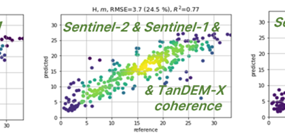
During the past six months we have been busy running hundreds of tests with different Earth observation (EO) data combinations and prediction algorithms in the seven testing sites in Europe and Peru. These tests were conducted to allow selection of optimal EO data and method combinations for the demonstrations to be implemented during the second year of the project.
Publications
14 posts

The findings of a recently concluded H2020 Forest Flux Innovation Action project will directly benefit our ongoing Forest Carbon Monitoring project.
Remote sensing observations from space are evolving to operational tools, possibly in complement with measurements taken on the ground. In the forestry sector, the use of satellite data is appealing because these cover large areas within a short period of time providing repeated snapshots of the landscape.
One of the scientific aspects to be further developed in the Forest Carbon Monitoring project is the integration of process-based forest ecosystem models into the forest biomass and carbon flux monitoring framework. The recent article ‘Demonstration of large area forest volume and primary production estimation approach based on Sentinel-2 imagery […]